Saturday 29 September 2007

It's a hard life - even for camels!

There can't be many places on earth which look as empty as this from above.. Mark is currently cycling through the district of Chagai, in the north west of the province of Pakistan. If you click on the hyperlink, you will link to a huge database of facts about the area. The section which deals with climate contains the following which goes a long way towards explaining the barrenness of the aerial photo....

The climate of the district ranges from extreme hot in summer to severe cold in winter. The difference between day and night temperature is considerable and the climatic conditions vary from area to area. Since the district falls outside the sphere of monsoon currents, the rainfall is irregular and scanty. The annual average rainfall in the district is 104 mm measured over the years 1993 - 1995. In the same period the average minimum temperature was 2.4 0C in January and maximum temperature 42.5 0C in July.

In these extreme climatic conditions even the camels must struggle

This is another photo from the journal of the couple who cycled to India last year http://www.cyclingtoindia.com/ , much of the way along the same route as Mark is following. I have been reading extracts from their diary in the last couple of days and the parts which deal with this leg of their journey are very illuminating!

According to his GPS tracker, Mark overnighted in Dalbandin.. It is hard to imagine how people sustain themselves in a town like this in the middle of a desert. With hardly a scrap of vegetation, there is clearly little cultivation possible. Having said that, there is some evidence that housing avoids the areas most prone to sheet wash when sudden rains in the surrounding hills will bring torrents of water through the town.


Dalbandin is one of the towns along the railway line through this part of Balochistan and a search on Flicker produced a photo of the station!

The search also produced an interesting menu from a 'hotel' in Dalbandin..


There is some choice for vegetarians though you may have to use a bit of imagination to work out what 'Aamlate' is!


Back on the road today, the going may be tough if this photo from another travel blog is to be believed


Earlier today, however, Mark passed close to the first real signs of cultivation in the region..The torrent course entering the view from the left obviously sustains cultivation in flooded fields on the surrounding flood plain.


Just south of Mark's route today and rising steeply from the desert plain to a height of over 3000m are the Ras Koh mountains, infamously noted as the location of Pakistan's nuclear bomb tests in 1998.

And finally (for today!) if proof were needed of the importance of water, albeit seasonal and infrequent, this view certainly has it!

Thursday 27 September 2007

Welcome to Pakistan!

I would like to be able to say that I know a lot more about the geography of Pakistan than I did about Iran...... but although I do remember teaching Pakistan many years ago, the detail is very sketchy. I feel another learning journey coming on!
A map is always a good place to start when looking at an area for the first time....
Mark crossed the border into Pakistan in that cleft of the country in the west near to where the frontiers of Pakistan, Iran and Afghanistan meet and is now heading east through the province of Balochistan.....

Balochistan is predominantly a desert plateau occupying the western half of the country. To the east is the Indus valley drained by the mighty River Indus which flows from the foothills of the Himalaya in the north of the country. The first part of Mark's journey is therefore through a landscape which is very similar to the desert lands of eastern Iran which he has just left.

Following up a link from the webdiaries on http://www.artemisworldcycle.com/ to http://www.cyclingtoindia.com/ , I came across some good images of this part of the route which help to portray something of the landscape in this part of Pakistan....

Wednesday 26 September 2007

Iran - the last lap

After a few unexpected 'detours' in the last couple of days, Mark has now completed the last lap of his journey through the amazing country that is Iran and has crossed the border into Pakistan.
Earlier today he passed through Zahedan, the last city in Iran before the border...The image above shows a 'meeting' of countries - Iran to the west, Afghanistan to the north east and Pakistan to the south east. The nature of that meeting is interesting - why would national borders be drawn in such a way? It isn't at all clear until you consult an atlas and find that the 'hub' of the frontiers is on the highest mountain in the area and so is a logical choice despite appearances.

Marks' journey through Iran has taught me an immense amount about the geography of a country I knew little about just two and a half weeks ago but it has taught me something else - that the mental maps we hold in our heads need to be challenged. I may not yet be ready to travel in the borderlands of Iran, Pakistan and Afghanistan but I'd love to go there and I doubt if I would have said that a few weeks ago.

So what is this frontierland of Iran like? Well, maybe it's time to get out of Google's sky and have a look. Here are a few images of Zahedan which I have gleaned from Flickr...

Misty early morning


...and this is a slum area in the north east of the city occupied by Afghan immigrants.


And here the face of 'a man from Zahedan'....


...and an Afghan shoemender working on the street of Zahedan.

Finally, a bit of trawling produced a short video of the road between Bam and Zahedan which Mark cycled along either yesterday or today. The reports of the buffeting winds are clearly not exaggerated!


Tuesday 25 September 2007

More worlds apart!

Before heading out on a day of fieldwork to the Cairngorms, I felt compelled to check Mark's GPS - it is getting seriously addictive! What I saw made me think that it might be quite interesting and thought provoking to compare where he is with our whereabouts today...
The first comparison is that this is the best Google does for the Cairngorms - nothing like the high quality, high resolution images we've been looking at for Iran where not only the roads but vehicles on the roads are visible. However, setting that aside, here we are looking down on mountains which rise to about 1200 metres from the Spey valley which lies at 250 metres. The valley is cultivated or grazed and the lower mountain slopes are forested, some in ancient pine woodland. The snow capped mountains have been carved by glaciers and fashioned by rivers and the weather. Today the temperature was 8 degrees in Aviemore and 3 degrees at the top of the Cairngorm Mountain railway and it was raining!

The other image, shows the desert of south east Iran at an altitude higher than the summit of Cairngorm. Nearby are mountain peaks rising to well over 2000metres.....
There is scarcely a scrap of vegetation visible, the temperature today was 28 degrees and there was wall to wall sunshine. As for the scenery ... well, in common with many deserts, its features are the result of erosion by wind and, surprisingly, water! Everywhere in this part of Iran there is evidence of the effects of water ....from gullies to wadis to the flow lines of sheet wash. When it rains, as it does infrequently,very little of the water released will infiltrate the hard ground. Instead, it will flow off over the surface in torrents carving channels and depositing large quantities of sediment over wide areas.

That fact may account for the linear feature (visible above and to the right) I spotted near the road Mark was on this morning. The resemblance with groynes on a beach is quite striking and I think it may serve a similar purpose in trapping and diverting water and sand which will sweep down the slope and possibly across the road when there are heavy rains. I reckon that water pools up behind the structure and then dries out leaving white mineral salts at the surface. Excess water is diverted away from the road off the end of the structure (bottom right).
Of course, I could be wrong.........

Monday 24 September 2007

A painted desert?

After the stars and stripes of yesterday, today's view from the air near to Mark's route reveals this amazing display of rainbow rocks. These are folded sedimentary rocks -laid down in ancient seas as layers of different types of sediments - sandstones, mudstones, shales, clays, gritstones, limestones etc - each layer with its own geologic properties and colours. The collision of great crustal plates in the last 60 million years resulted in these layers being uplifted and folded to reveal their glory in mountains rising to heights of 2000 metres. It is through here that Mark has been cycling today.

The beauty of the colours is even more apparent in a closer view. The change of hue is so subtle it reminds me of a shade card! However, there is more in the view than just colourful rocks.....

The 'river' is a wadi which , viewed nore closely, will look like this . Wadis are dry river beds filled with sediments carried when the rivers are in seasonal flash flood mode. These rivers rise very quickly in response to the rare rain events but their levels also fall quickly as the water is absorbed and evaporated, depositing the sediments in the river channels.

Sunday 23 September 2007

Bam

According to his GPS tracker, Mark reached Bam today at 14.00 GMT. From the air it looks much like many of the other settlements on the edge of the desert which he has travelled through in the last couple of days. Like Rafsanjan and Kerman, it is located where a seasonal river provides enough water to support irrigation and cultivation. Unlike Rafsanjan and Kerman, however, it is not its agricultural commodities or Persian carpets for which it is noted but rather the huge death toll which followed an earthquake there on 26th December 2003. A closer look at the area from the air reveals clear evidence of the disaster...
..temporary shelters (probably tents) surrounded by buildings which lie destroyed. This imagery is probably a couple of years old but judging from the extent of the destruction visible in the city, it is doubtful if much reconstruction will yet have been achieved.

I have been saying that I know very little about the geography of Iran (much more now though having followed Mark through the country for two weeks) but ironically, the Bam earthquake and its aftermath I know quite well. Contrary to what some people may say, geography teachers do not 'enjoy' a good natural hazard but we do try to make sense of them for our pupils. Pupils need to understand where and why these natural phenomena occur but, more importantly, realise that it is the state of preparedness of the population which turns a hazard into a disaster. Some societies can prepare better than others. There is a very good exemplification of that idea here.

As for the disaster in Bam, there is an abundance of material which I can share with you, much of it courtesy of two 'virtual' colleagues, (Geography teachers in England), who put together links on their school blogs to web based video footage, photographic records and newspaper reports. Look here and here for their treasury of resources.

Sadly the 2000 year old citadel, one of the largest adobe mud structures in the world and seen here before 2003, was virtually destroyed by the 'quake.
With thanks to my two virtual colleagues Rob Chambers and Noel Jenkins who have saved me a lot of surfing this evening.

Stars and stripes!

I hadn't intended to geo-blog today - or, at least, I thought I'd wait until Mark reached Bam but my roving eye got the better of me! Just some 50-100km to the north east of the road along which Mark is cycling this morning are some amazing patterns in the desert...
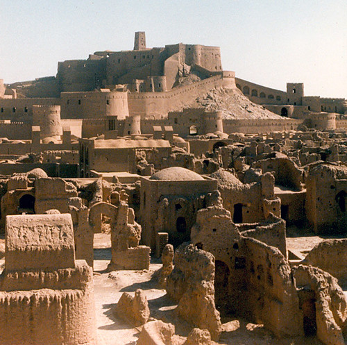
To the west are these stripes . It is really difficult to work out what you are looking at here but stripes in deserts are not uncommon and often are associated with seif dunes which form parallel to the main wind direction or with yardangs which are linear ridges eroded by wind blown sand. I do wonder if what we are seeing here could be wind eroded ridges - covered in salt - a bit like the salt flats we've already looked at in Dasht e Kavir further north but modified by the effects of the wind. It's at moments like this that I wish we could persuade Mark to take a detour! To the east, however, the patterns are much easier to decipher...
...and are unmistakeably sand dunes which, according to my atlas, form the southern end of the second of Iran's great deserts, the Dasht e Lut. Zooming in more closely on one part of the dunes , I am seeing stars!

These dunes with three or more radiating legs are called star dunes and are most likely caused when winds blow from a number of directions, probably shifting with the seasons. On the ground they look like this ..
And finally.... a bit of trawling produced this image of the Dasht e Lut

The more I find out about Iran, the more I feel I need to get there.

P.S. re 'the stripes', I have just found this. I am relieved to read that I wasn't far out!

Saturday 22 September 2007

Pie charts and pistachios

You cannot look at the route Mark has been following for the last couple of days without noticing the effect that the availability of irrigation has on the landscape ...The ribbons of green stand out clearly in this otherwise arid landscape. To understand how significant they are, you need to bear in mind that this area IS a desert - with average monthly totals of precipitaion in mm as follows (Jan to Dec in Kerman)
29.0, 26.7, 32.0, 19.5, 8.6, 0.5, 0.7, 0.6, 0.3, 0.7, 5.1, 18.6 . This adds up to an annual total of just 142.1 mm. Now, as all good students of Geography should know, anywhere receiving less that 250mm is officially a desert! So Kerman is not just a desert but it is a very dry desert. To put Kerman's annual rainfall total into context, Glasgow receives 1500mm of rain annually while the east coast of Scotland has about 750mm.

142mm of rain (much of it falling when high temperatures will instantly evaporate it), is just not enough rain to sustain cultivation. Thus , our ribbons of green will be entirely dependent on irrigation. So where does the water come from? You have to remember that this area is surrounded by mountains which rise to between 2000m and 3000m. Snow will accumulate there in the winter and melt in spring so there will be surface water available which can be stored in mountain dams and released down the valleys at various times during the year. Here, for example, is a dam I 'found' by scanning the mountains just south of Rafsanjan.

In addition to the surface water,there are also ground water sources which can be tapped.

When roaming over the area between Rafsanjan and Kerman, I also came across these features which, for once, I can explain....


What looks like pie charts are actually centre pivot irrigation systems. So what is all this irrigation for? What crops are producing the ribbons of green on the map? Well, it seems that this part of Iran produces pistachios .... a LOT of them. Iran is in fact the largest producer of pistachios in the world and the desert border through which Mark is currently cycling is the main area for production. Clicking here will take you to a website entirely devoted to information about Iranian pistachios! From what I have read, it would seem that this part of Iran has the ideal climate for pistachio production..... short cold winters, long very hot summers, low humidity and the possibility of infrequent irrigation.

And in case you are wondering how they grow, here are some fruiting pistachios. They look like pink flowers but the nuts are inside the pink shells. When fully ripe, the shells are blanched by the sun and split open.

Mark cycled through the city of Kerman today but probably had little time for sight seeing. We, though, do have the chance to soak in some of the sights of the city.

Thursday 20 September 2007

What a relief!

One of my (very) few disappointments with Google earth/map imagery is that it can be very difficult to get any idea of relief. Mountains often don't look very big and the summits can seem like the valleys and vice versa. Today's latest GPS plot is a good example of this. The minor road heading west looks like it crosses a summit when in fact it is following the valley ...The aerial view shows Mark heading south from Yazd with some high terrain to his west. I happened to look at the atlas and saw that this high terrain is in fact a mountain peak called Shir Kuh which rises to over 4000 metres. This will be the sort of view which Mark has had this morning (though probably with less snow on it). This photo of the mountain is again from the galleries of Brian McMorrow which I discovered yesterday as a source of lovely images of the region. Here is another which illustrates the difficulty of reading road signs in Iran .....


I have also finally found a good relief map of Iran - in German but it serves the purpose...

There is not a lot of low, flat land in Iran! Having cycled along the grain of the Elburz mountains in the north, Mark is now following the Zagros mountains in the west.

Wednesday 19 September 2007

Yazd

Mark reached the city of Yazd this afternoon and with imagery as good as this, you really get the feeling of being there with him!

So today, having already found out a fair bit about the physical geography of Iran, Yazd presents us with a good opportunity to find out something of the human geography of the country. ... except, as we will see see, the human geography is often dictated by physical factors


The aerial photo above shows a tiny corner of this city of over 433,000 people. That makes it more or less the same size as Edinburgh! Even this tiny part of the city shows buildings constructed to create maximum shade in inner courtyards. As the temperature figures for Yazd reveal - 40 degrees is not uncommon in summer - shade will be at a premium. Traditional architecture responds to this climate as this article from Wikipedia explains. Many of the buildings in Yazd benefit from a type of natural air conditioning called windcatchers and are supplied by water from underground sources via qanats. Yazd is also one of the largest cities built almost entirely out of adobe mud bricks. Adobe has particularly good insulation properties and keeps buildings cool in summer but prevents too much heat from being lost in the cold winter months.


To get a really good impression of the architecture and history of the city, you might like to watch this video..


The narrator has a slightly tedious voice but the video is definitely worth watching! if the embedded version fails to play, click here.

Perhaps even better, however, are these galleries of stunning photographs by photographer Brian McMorrow. If you link to the webpage and click on any of the thumbnails, they open dozens of really high quality photos of Yazd.

Monday 17 September 2007

Big white blob!

It was impossible to follow Mark's route today south of Qom and not be struck by the huge expanse of white which lay some 20 kms to his east. Investigation reveals that this area is right on the edge of the 400,000 hectare Kavir National Park . The white 'blob' is a salt lake known as Daracheh ye Namak. There is a really excellent aerial photo of the national park here on NASA's Earth Observatory website along with a good description of the area.

One of the striking features of the photo is that despite the current aridity of the area (it receives only around 150mm of rain per year), there has clearly been a lot of water around at some time in the past to create these 'fans' of material which have been washed down from the high ground in the middle of the national park.

As for the white blob, here's what it looks like at close quarters...

Sunday 16 September 2007

Worlds apart

Over the last couple of days, Mark has headed south away from the Elburz mountains and has therefore 'avoided' Tehran, the capital city of Iran. Given that it has a population of 11 million and is located at the hub of road and rail communications in the country , 'avoiding' Tehran is probably a very wise decision! The city skyline and the link (above ) should help to fill in a little about this city for those who are interested.
Meanwhile, the road for Mark has been south east towards Qom. At this point it is probably worth 'revisiting' the geography of the whole of Iran. The population distribution is markedly uneven as the following map shows ...
Even without detail in the key, the north and west is clearly much more densely populated than the south and east of the country. There are good 'geographical' reasons for this and principal amongst them will be terrain, climate and natural resources. It is not easy to get a good on-line relief map of Iran but this one does give some impression of the terrain in the north of the country...Surprisingly, it would seem that most of Iran's population live in the mountainous areas of the north and west. The reason is that to the east is a huge salt desert plateau called Dasht e Kavir. If I am honest, I'm not sure that I know what a salt desert is but I've found a few people who do! If you click the link above you can read what Wikipedia has to say on the subject. This NASA photo is stunning and this is their explanation ..."The Dasht-e Kevir, or Great Salt Desert, is the largest desert in Iran. It is primarily uninhabited wasteland, composed of mud and salt marshes covered with crusts of salt that protect the meagre moisture from completely evaporating. " If you still can't get a picture of what this desert is like, try this lovely set of photos on Flickr or this interesting photo and accompanying note.

Mark is now skirting the Great Salt Desert on its western edge and has today passed the city of Qom .

Today, half a world away, I've been doing fieldwork with Advanced Higher Geography pupils. We were working in Strathardle, between Pitlochry and Blairgowrie and by a curious coincidence, this is where Mark grew up and went to primary school. I bet it didn't rain all weekend in Qom though!!